This briefing reviews preliminary hydrological observations, satellite interpretations from the Department of Hydrology and Meteorology (DHM), and field reports from district responders.
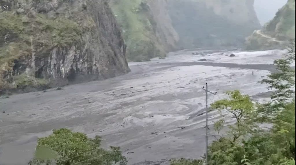
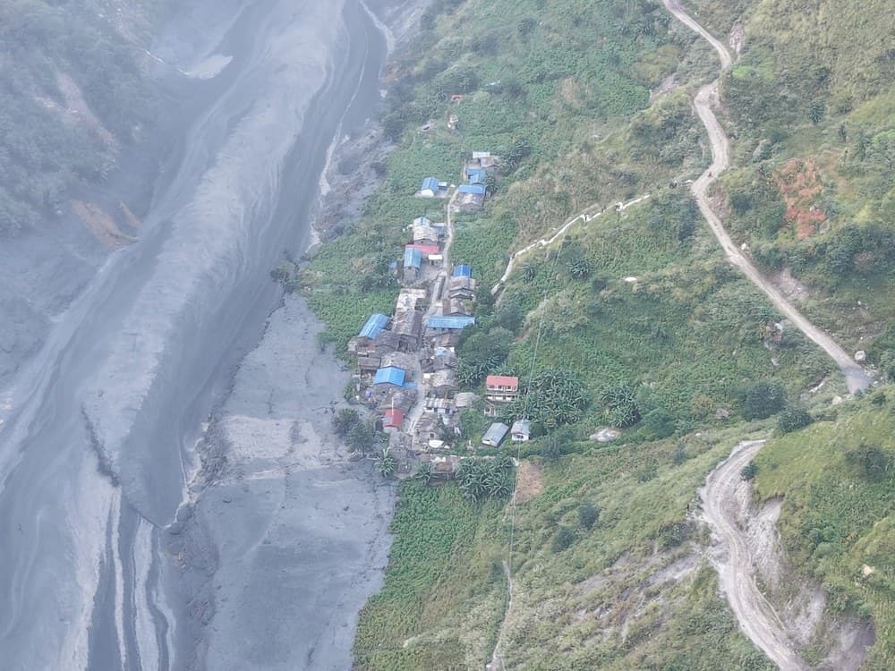
Weather monitoring stations in upper northern Gorkha logged no intense cloudbursts on Sunday morning. Yet, without heavy rainfall, a sudden pulse of dark mud, timber, and sediment surged down the Budhi Gandaki river gorge, tearing away bridges and threatening riverside settlements.
1. What is Currently Known About the Cause
Hydrological stations and local observers documented several key physical characteristics during Sunday’s flood:
- Dense Mud and Debris Slurry: The surge was characterized by thick black sediment, uprooted logs, and rock debris rather than typical rain-fed surface runoff.
- No Heavy Rainfall Recorded: According to DHM's Flood Forecasting Division, automated telemetric rain gauges in the upper Manaslu and Chumnubri catchment registered no extreme precipitation capable of generating this sudden volume.
- Aarughat Gauge Spike: The hydrometric station at Aarughat registered a rapid water level increase, reaching 5.1 metres and crossing the 5.0-metre danger threshold on Sunday morning before receding and fluctuating.
2. Attributed Preliminary Assessments
Because intense rainfall was absent, geologists and disaster officials are investigating upstream slope failures as the primary suspected trigger:
In an interview reported by The Kathmandu Post, senior hydrologist Binod Parajuli of DHM stated that preliminary satellite imagery showed evidence of a massive landslide around Chumchet in Chumnubri Rural Municipality-6. Parajuli indicated that the detachment appeared to have formed Saturday, and the flood likely resulted when a blocked tributary dam impounded water and suddenly gave way.
Separately, field reconnaissance reported by the Nepal Army and published by Onlinekhabar indicated that troops deployed from the Rudradhwoj Battalion Bangsing Post observed a dry landslide near Philim (Chumnubri Ward 3) that had obstructed streamflow before being breached.
Dr. Dharmaraj Upreti, Executive Director of the National Disaster Risk Reduction and Management Authority (NDRRMA), also confirmed that initial assessments point toward a sudden release of impounded river water rather than a conventional rain flood.
3. Understanding Natural River Blockages
In steep Himalayan canyons, slope failures can temporarily dam rivers. Research into natural dam processes, such as the seminal study by Costa & Schuster (1988) published by the U.S. Geological Survey (USGS), documents how unconsolidated debris dams form and breach:
Channel Obstruction: Rockfalls or landslides deposit unconsolidated rock, soil, and vegetation into narrow gorges, creating a temporary barrier.
Overtopping and Erosion: Unlike engineered structures, natural dams lack reinforced spillways. As water ponds upstream, hydrostatic pressure mounts until water overtops the lowest rim, rapidly eroding a breach channel through unconsolidated materials.
Flow Fluctuations: If sidewalls continue to collapse into the breach channel or debris jams form downstream, water discharge can surge in intermittent pulses rather than a single uniform flood wave.
Note: While scientific literature describes typical landslide dam behavior, only detailed ground and aerial surveys can confirm the exact mechanics and dimensions of this specific event.
4. What is Known vs. What is Under Investigation
| Observation Status | Key Findings | Primary Source Attribution |
|---|---|---|
| Directly Documented | Debris-heavy surge, Aarughat gauge reading 5.1m, absence of heavy local rain, bridge damage. | DHM hydrometric telemetry, District Police, field teams |
| Preliminary Assessment | Landslide damming and breach suspected; scars observed near Chumchet and Philim. | DHM satellite analysis, Nepal Army ground reconnaissance |
| Under Investigation | Exact dam volume, local claims of an avalanche on Mount Shringi, precise trigger timing. | Awaiting foot patrol and clear aerial verification |
| Not Confirmed | Not confirmed as a Glacial Lake Outburst Flood (GLOF); no alpine moraine lake rupture identified. | DHM / NDRRMA technical overviews |
5. Warning History and Downstream Advisories
Safety alerts evolved as hydrologists tracked the pulse moving downstream toward the Trishuli and Narayani river systems:
- 08:55 NPT (Benighat Early Assessment Published): In an analysis published by Onlinekhabar at 08:55 AM, hydrologist Binod Parajuli indicated that because Aarughat had crested and the river corridor broadens considerably at the Trishuli confluence (Benighat), immediate high-risk flooding downstream of Benighat was not anticipated at that specific time.
- Midday Precautionary Expansion: Because river levels upstream continued to fluctuate, disaster authorities widened precautionary notices to low-lying river terraces across six districts: Gorkha, Dhading, Tanahun, Chitwan, Nawalparasi East, and Nawalparasi West.
6. Frequently Asked Questions
Has the exact trigger of the flood been confirmed?
No. Authorities and hydrologists suspect that a dry landslide created a temporary dam that subsequently failed. Definitive confirmation requires on-site technical inspection once terrain conditions permit.
Was this a Glacial Lake Outburst Flood (GLOF)?
Current technical assessments have not confirmed a GLOF. Satellite reviews indicate mass movement on slopes rather than the breach of an alpine glacial lake.
Does a temporary drop in river level mean the hazard has passed?
Not necessarily. During mass-movement events, a temporary drop in water level can indicate that sediment or rock has formed a secondary blockage upstream, which could later release another surge.
Where can the public find verified river bulletins?
Consult the Department of Hydrology and Meteorology, dial the toll-free flood information hotline 1155, or check the NDRRMA BIPAD portal.
7. Related HamroBuzz Reports
- Damage Assessment: Budhi Gandaki Flash Flood: Settlements and Bridges Damaged Across Gorkha as Riverside Communities Evacuate
- Rescue Operations: Budhi Gandaki Flood Rescue: Nepal Army Reports 36 Rescued; Missing Persons Under Active Investigation
Sources, Citations & Permissions:
- Official Agencies: Department of Hydrology and Meteorology (dhm.gov.np; flood hotline 1155); National Disaster Risk Reduction and Management Authority (bipadportal.gov.np).
- Field Reconnaissance: Nepal Army Directorate of Public Relations and Information via Onlinekhabar report 2036748.
- News Reporting: Hariram Uprety, The Kathmandu Post (October 11, 2026); Onlinekhabar (08:55 AM report).
- Scientific Reference: Costa, J.E. & Schuster, R.L. (1988), The formation and failure of natural dams, USGS Publication 70013832. (Cited as general academic context on natural-dam mechanics).
- Image Attribution & Usage: Image by Hariram Uprety / The Kathmandu Post reproduced under editorial review with attribution.